Transit network
BART and Muni Metro lines through San Francisco as polylines with a white casing, stations as small SVG markers and station names as labels next to them. Where BART and Muni share Market Street, Muni is drawn beside BART.
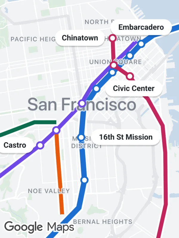
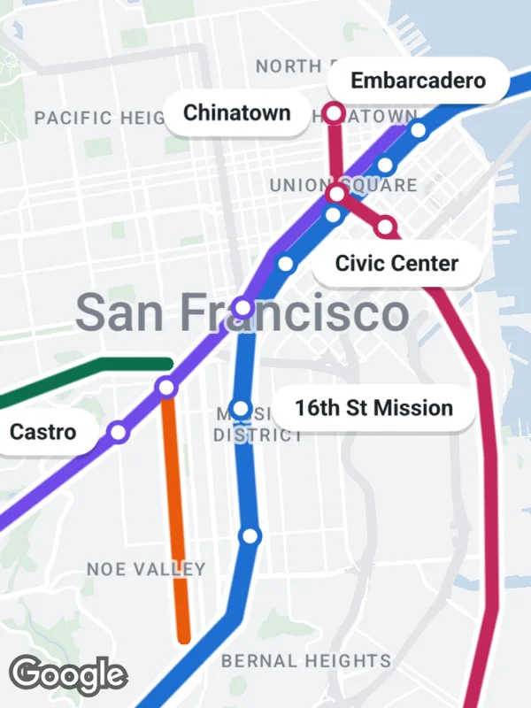
transit.tsx
import React from 'react';

import {
  GoogleMapsView,
  type RNLatLng,
  type RNPolyline,
} from 'react-native-google-maps-plus';

import {
  ABOVE,
  GREEN,
  LEFT,
  RIGHT,
  Z,
  dot,
  label,
  lightStyle,
  ll,
  marker,
} from './shared';

const BART = '#1c6dd0';
const MUNI = '#7048e8';
const J_CHURCH = '#e8590c';
const T_THIRD = '#c2255c';

// Muni runs next to BART under Market Street, offset to the north west.
const besideBart = (p: RNLatLng) =>
  ll(p.latitude + 0.0011, p.longitude - 0.0015);

const bart = [
  ll(37.8044, -122.33),
  ll(37.8, -122.3745),
  ll(37.7955, -122.3925),
  ll(37.7929, -122.3971), // Embarcadero
  ll(37.7894, -122.4013), // Montgomery St
  ll(37.7844, -122.4079), // Powell St
  ll(37.7795, -122.4139), // Civic Center
  ll(37.7738, -122.4187),
  ll(37.765, -122.4196), // 16th St Mission
  ll(37.7522, -122.4184), // 24th St Mission
  ll(37.744, -122.4205),
  ll(37.7331, -122.4338), // Glen Park
  ll(37.7219, -122.4474), // Balboa Park
];
const bartStations = [3, 4, 5, 6, 8, 9, 11, 12];

const muni = [
  besideBart(bart[3]!),
  besideBart(bart[4]!),
  besideBart(bart[5]!),
  besideBart(bart[6]!),
  ll(37.7765, -122.4185),
  ll(37.7751, -122.4193), // Van Ness
  ll(37.7671, -122.429), // Church
  ll(37.7626, -122.4351), // Castro
  ll(37.7481, -122.459), // Forest Hill
  ll(37.7408, -122.4656), // West Portal
];
const muniStations = [5, 6, 7, 8, 9];

const nJudah = [
  ll(37.7695, -122.429),
  ll(37.7695, -122.4372),
  ll(37.7657, -122.4498),
  ll(37.7621, -122.4664),
  ll(37.7605, -122.5089),
];

const jChurch = [
  ll(37.7671, -122.429),
  ll(37.7605, -122.4285),
  ll(37.7505, -122.4275),
  ll(37.742, -122.4268),
];

const tThird = [
  ll(37.7946, -122.4078), // Chinatown
  ll(37.7865, -122.4074), // Union Square
  ll(37.7832, -122.4013), // Yerba Buena
  ll(37.7786, -122.3973), // 4th and Brannan
  ll(37.7765, -122.3946),
  ll(37.7685, -122.389),
  ll(37.7604, -122.388),
  ll(37.745, -122.3878),
  ll(37.733, -122.3912),
];
const tStations = [0, 1, 2, 3];

// Lines are drawn with a white casing, the casings stay below all lines.
function line(
  id: string,
  coordinates: RNLatLng[],
  color: string,
  width: number
) {
  const base = { coordinates, lineCap: 'round', lineJoin: 'round' } as const;
  return [
    {
      ...base,
      id: `${id}-casing`,
      color: '#ffffff',
      width: width + 5,
      zIndex: 1,
    },
    { ...base, id, color, width, zIndex: 2 },
  ] satisfies RNPolyline[];
}

const stations = (
  prefix: string,
  points: RNLatLng[],
  indices: number[],
  color: string
) =>
  indices.map((i) =>
    marker(`${prefix}-${i}`, points[i]!, dot(color, 3.5, 2.5), {
      zIndex: Z.dot,
    })
  );

export default function TransitNetwork() {
  return (
    <GoogleMapsView
      style={{ flex: 1 }}
      customMapStyle={lightStyle}
      mapOptions={{ camera: { center: ll(37.7705, -122.4165), zoom: 12.4 } }}
      polylines={[
        ...line('bart', bart, BART, 8),
        ...line('muni', muni, MUNI, 6),
        ...line('n-judah', nJudah, GREEN, 6),
        ...line('j-church', jChurch, J_CHURCH, 6),
        ...line('t-third', tThird, T_THIRD, 6),
      ]}
      markers={[
        ...stations('bart', bart, bartStations, BART),
        ...stations('muni', muni, muniStations, MUNI),
        ...stations('t', tThird, tStations, T_THIRD),
        label('embarcadero', bart[3]!, 'Embarcadero', ABOVE, { size: 11 }),
        label('civic-center', bart[6]!, 'Civic Center', RIGHT, { size: 11 }),
        label('16th', bart[8]!, '16th St Mission', RIGHT, { size: 11 }),
        label('castro', muni[7]!, 'Castro', LEFT, { size: 11 }),
        label('chinatown', tThird[0]!, 'Chinatown', LEFT, { size: 11 }),
      ]}
    />
  );
}
Colors, map styles and the SVG helpers svg, marker and pill come from shared.ts. Marker text uses the Roboto fonts bundled with the example app, see fonts.